Love waking up to mountain panoramas, trailheads close by, and quick access to Bend’s favorite spots? If that sounds like your kind of day, Awbrey Butte might be a great fit. You get quiet streets, mature pines, and larger lots, along with ridge-top parks and nearby river paths. In this guide, you’ll learn what it feels like to live on the butte, how the trail network works, what housing looks like, and the practical checks to do before you buy. Let’s dive in.
Awbrey Butte at a glance
Awbrey Butte rises above the Deschutes River on Bend’s west side and is the highest point within city limits at about 4,214 feet, which explains the broad views and steeper streets in spots. You’ll find mostly single-family, custom homes set among ponderosa pines, with privacy and views as key draws. The area reads quiet and residential, and most residents drive to nearby commercial areas for daily needs.
Geography and everyday feel
Awbrey Butte is a true volcanic butte, with basalt geology that creates exposed rock outcrops and varied slopes. West and south orientations often deliver Cascade Range panoramas on clear days, while other homes look over the river corridor and city lights. Expect big-sky sunsets, tree-framed decks, and a sense of elevation that feels calm and secluded.
Because the neighborhood is primarily residential, you will drive for most errands. Many residents head to Newport Avenue, the Old Mill District, or NorthWest Crossing for groceries, coffee, and dining. Daily life feels easygoing and outdoors-forward, with quick choices between ridge walks, forest loops, and flat river paths.
Trails, parks, and ridge walks
If trails are nonnegotiable for you, Awbrey Butte checks that box. Several neighborhood parks and nearby trail systems create a flexible web of short walks and longer outings.
- Summit Park: This small, high-elevation park on the butte offers open lawns, tennis, and picnic space, plus unpaved connections downhill toward Sylvan Park. Explore the amenities and setting on the Bend Park & Recreation District’s page for Summit Park.
- Sylvan Park: Listed by BPRD as one of the district’s highest-elevation parks, Sylvan serves as a hub for natural-area paths and ridge-top strolls. A playground renovation is planned, so check the Sylvan Park project page for updates and timing.
- Shevlin Park: Just a short drive from the butte, Shevlin Park’s pine forest, creek canyon, and loop trails make it a go-to for hiking and running. You can review route options and distances on the Shevlin Park trails page.
- Deschutes River Trail, Awbrey reach: At the base of the butte, the river trail provides flatter, paved walking and cycling that links toward downtown and the Old Mill. For an overview of the butte and river connections, see the local guide to Awbrey Butte’s neighborhood amenities.
Mountain biking access
Awbrey Butte sits within easy reach of Bend’s signature singletrack. The west-side trailheads are a straight shot from the neighborhood.
- Phil’s Trailhead and network: The Phil’s complex is a regional mountain-biking destination with routes for a range of skill levels. Start with the official Phil’s Trailhead page for maps and updates.
- Seasonal closures: Sections of trail can close based on conditions and stewardship work. Before a big ride, scan local notices like this overview of Phil’s Trail closures so you can plan the right loop.
Golf and river recreation nearby
Two well-known golf options sit beside the butte, shaping lifestyle and social choices.
- Awbrey Glen: A private club community with course, dining, and member amenities.
- River’s Edge: A public 18-hole course with broad city views and events. For course summaries and access types, see the Bend Bulletin’s Central Oregon golf course guide.
Combine that with the Deschutes River pathway below and you get easy transitions from tee times to sunset walks along the water.
Homes, lots, and architecture
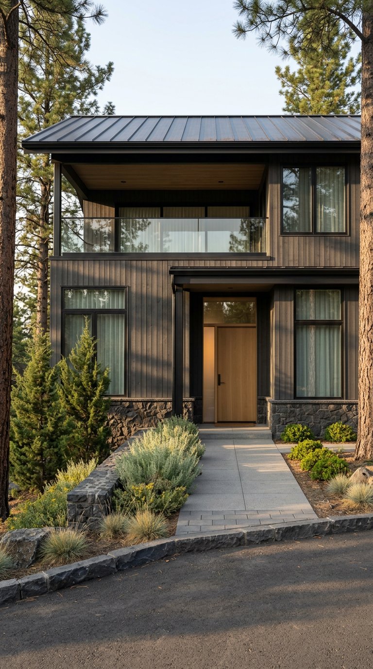
Awbrey Butte is known for custom single-family homes that range from 1980s builds to recent construction. You’ll see styles from ranch and Craftsman to Northwest contemporary and mountain modern. Many lots are larger than inner-city parcels, often about a quarter to a half acre in parts of the butte, which supports privacy and outdoor living. Some areas include gated streets or golf-course subdivisions, while others sit within a standard Bend neighborhood pattern.
Certain subdivisions and golf communities have CC&Rs or HOAs. If a property interests you, request the CC&Rs and any HOA disclosures up front so you understand architectural guidelines, landscaping rules, and fee structures.
Access, driving, and commute notes
Walkability is generally low. Most residents drive to shopping, schools, and dining, although short neighborhood walks to parks are common. Transit serves Bend broadly, but schedules and routes vary, so most households plan around a personal vehicle. The tradeoff is quick access to ridge parks, mountain bike trailheads, and the river corridor.
Market snapshot and what it means for you
Recent neighborhood reports show Awbrey Butte trading at a higher Bend price point, with a median sale price around 1.1 million dollars in early 2026 and longer days on market than some in-town areas. Because market conditions shift quickly, verify current comps and absorption before you write an offer. A strategy-first approach helps you pinpoint value, understand pricing for specific view corridors, and negotiate from a position of clarity.
Practical buyer checklist
Every hillside neighborhood has a few details you should check. On Awbrey Butte, these are the big ones:
- Views and orientation: Confirm actual sightlines on a clear day. Mountain views depend on lot orientation and tree cover. Ask for seller photos, study listing angles, and bring a compass.
- Winter driving and plowing: Steeper local streets can feel different in snow. The City of Bend publishes winter maintenance and plowing priorities. Review city guidance on bendoregon.gov and consider a test drive after a storm if timing allows.
- Stormwater and drainage: City engineering notes the butte’s steep slopes and drainage considerations. Budget for appropriate grading, gutters, and landscape planning on sloped lots, and review the City’s stormwater and slope context as part of due diligence.
- Wildfire and defensible space: Use the Oregon Wildfire Risk Explorer to understand property-specific hazard and plan vegetation management. Start with the ODF–OSU technical guide to the hazard map.
- Utilities and entitlements: Most city parcels have municipal water and sewer, but confirm service for any older or edge parcels with your title report and the City.
- Schools and attendance areas: Public school assignments vary by address. Confirm a property’s assigned schools using the Bend–La Pine attendance-area lookup.
How it compares to nearby areas
If you are deciding between west-side neighborhoods, this quick compare can help frame tradeoffs:
- Awbrey Butte vs. NorthWest Crossing: Awbrey Butte favors elevation, views, and larger lots. NorthWest Crossing centers on walkability, a village core, and nearby shops. For an area overview and amenities context, see this Awbrey Butte neighborhood guide.
- Awbrey Butte vs. Tetherow: Both are scenic and elevated. Tetherow is a newer, resort-style planned community with on-site amenities. Awbrey Butte is a mature mix of custom homes and golf neighborhoods with immediate ridge-top parks.
- Awbrey Butte vs. River West/Old Mill: River West and Old Mill are flatter and place you closer to restaurants and riverfront retail. Awbrey Butte trades that for privacy, bigger yards, and expansive views.
Who loves living here
You may be a good fit for Awbrey Butte if you want:
- Cascade views or city-light outlooks on clear days.
- Ridge parks, river paths, and quick access to the west-side trail network.
- A quieter, residential setting with larger lots and custom homes.
- Proximity to private and public golf options without living far from town.
If that aligns with your goals, a targeted search will help you balance orientation, lot size, and street grade so the home fits your day-to-day life.
Ready to explore Awbrey Butte with a local guide who understands view corridors, microclimates, and value drivers on the hill? Schedule a confidential consultation with Silvia Giffin-Knight to build your plan.
FAQs
What makes Awbrey Butte unique within Bend?
- It is the city’s highest point at about 4,214 feet, which creates wide views, steeper streets in places, and a quiet, residential feel supported by ridge-top parks and nearby trail networks. See the City’s topography and slope context for background.
How close are Awbrey Butte homes to trails and parks?
- Many homes are minutes from neighborhood parks like Summit Park and Sylvan Park, with longer loops at Shevlin Park and flat pathways on the Deschutes River Trail below the butte.
Is Awbrey Butte walkable for daily errands?
- Walkability is generally low. You will likely drive to groceries, dining, and services, but short neighborhood walks to parks and viewpoints are common, and the river trail provides a flat, paved option at the base of the hill.
What should buyers check about winter and drainage on the butte?
- Test-drive steep streets after a snowfall if possible, review City plowing priorities on bendoregon.gov, and evaluate sloped-lot drainage against the City’s stormwater guidance during inspections.
Which schools serve Awbrey Butte addresses?
- School assignments vary by address. Confirm each property’s assigned schools using the Bend–La Pine attendance-area lookup.
Where do Awbrey Butte residents mountain bike?
- Many ride from the west side to the Phil’s Trailhead network, checking seasonal updates and any closures via local stewardship notes like this Phil’s closures overview.